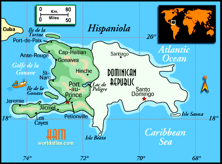
 Geography has never been one of my strong points. With the recent news of the death and destruction caused by the earthquake in Haiti, I figured it was time to look up Haiti's exact location on a map. If you live in the U.S. you can get there using the following directions:
1. Start at the southern tip of Florida.
2. Swim due south until you run into Cuba.
3. Walk east until you run out of island.
4. Swim east-south-east (this is a much shorter swim than the one from Florida) until you hit the island of Hispaniola, on which Haiti is located.
Hispaniola is the second largest island in the Caribbean behind Cuba. Haiti makes up the western one-third of the island of Hispaniola; the Dominican Republic makes up the eastern two-thirds of the island.
No comments:
Post a Comment